Natural Disasters Disasters
The fifteen volcanoes that make up the eight principal islands of Hawaii are the youngest in a chain of more than 129 volcanoes that stretch 5,800 kilometres (3,600 mi) across the North Pacific Ocean, called the Hawaiian-Emperor seamount chain. Hawaiʻi's volcanoes rise an average of 4,572 metres (15,000 ft) to reach sea level from their base. The largest, Mauna Loa, is 4,169 metres (13,678 ft) high. As shield volcanoes, they are built by accumulated lava flows, growing a few meters/feet at a time to form a broad and gently sloping shape.
Hawaiian volcanoes all follow a specific pattern of eruption, building, and erosion. Hawaiian islands undergo a systematic pattern of submarine and subaerial growth that is followed by erosion. An island's stage of development reflects its distance from the Hawaii hotspot. More details
The island of Hawaii is built from five separate shield volcanoes that erupted somewhat sequentially, one overlapping the other. These volcanoes are: Kīlauea, Mauna Loa, Hualālai, Mauna Kea and Kohala. More details
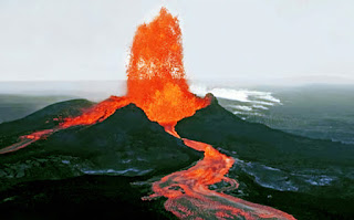
Kīlauea is an active shield volcano in the Hawaiian Islands that last erupted between 1983 and 2018. Historically, Kīlauea is the most active of the five volcanoes that together form the island of Hawaiʻi. Located along the southeastern shore of the island, the volcano is between 210,000 and 280,000 years old and emerged above sea level about 100,000 years ago.
It is the second youngest product of the Hawaiian hotspot and the current eruptive center of the Hawaiian–Emperor seamount chain. Because it lacks topographic prominence and its activities historically coincided with those of Mauna Loa, Kīlauea was once thought to be a satellite of its much larger neighbor. Structurally, Kīlauea has a large, fairly recently formed caldera at its summit and two active rift zones, one extending 125 km (78 mi) east and the other 35 km (22 mi) west, as an active fault of unknown depth moving vertically an average of 2 to 20 mm (0.1 to 0.8 in) per year.
Kīlauea erupted nearly continuously from 1983 to 2018, causing considerable property damage, including the destruction of the towns of Kalapana and Kaimū along with the renowned black sand beach, in 1990. During the 2018 lower Puna eruption, two dozen lava vents erupted downrift from the summit in Puna. The eruption was accompanied by a strong earthquake on May 4 of Mw 6.9, and nearly 2,000 residents were evacuated from the rural Leilani Estates subdivision and nearby areas.
On May 17, 2018 the volcano explosively erupted at the summit in Halemaʻumaʻu, throwing ash 30,000 feet into the air. Continued explosive activity at the summit caused a months-long closure of the Kīlauea section of Hawaii Volcanoes National Park. Vigorous eruptive lava fountains in lower Puna sent destructive rivers of molten rock into the ocean in three places. The lava destroyed Hawaii's largest natural freshwater lake, covered substantial portions of Leilani Estates and Lanipuna Gardens, and completely inundated the communities of Kapoho, Vacationland Hawaii and most of the Kapoho Beach Lots. More details
The island of Hawaii is built from five separate shield volcanoes that erupted somewhat sequentially, one overlapping the other. These volcanoes are: Kīlauea, Mauna Loa, Hualālai, Mauna Kea and Kohala. More details
Kīlauea is an active shield volcano in the Hawaiian Islands that last erupted between 1983 and 2018. Historically, Kīlauea is the most active of the five volcanoes that together form the island of Hawaiʻi. Located along the southeastern shore of the island, the volcano is between 210,000 and 280,000 years old and emerged above sea level about 100,000 years ago.
It is the second youngest product of the Hawaiian hotspot and the current eruptive center of the Hawaiian–Emperor seamount chain. Because it lacks topographic prominence and its activities historically coincided with those of Mauna Loa, Kīlauea was once thought to be a satellite of its much larger neighbor. Structurally, Kīlauea has a large, fairly recently formed caldera at its summit and two active rift zones, one extending 125 km (78 mi) east and the other 35 km (22 mi) west, as an active fault of unknown depth moving vertically an average of 2 to 20 mm (0.1 to 0.8 in) per year.

